Advanced Geolocation Intelligence: Visual Analysis Without Metadata
How Bower's AI identifies precise locations through visual analysis without relying on metadata or EXIF data, revolutionizing geolocation intelligence for the modern world.

In today's digital landscape, visual content is everywhere—but extracting meaningful location information from images remains a complex challenge. While traditional methods rely on GPS metadata and EXIF data, these approaches often fail when dealing with real-world scenarios where such information is stripped, manipulated, or simply unavailable.
At Bower, we've developed a breakthrough approach to geolocation analysis that mimics human visual perception, identifying locations through pure image analysis without requiring any metadata. This technology represents a fundamental shift in how we understand and process geographical information from visual data.
The Challenge We Solved
Traditional geolocation methods rely heavily on metadata, GPS coordinates, or EXIF data embedded in images. However, this approach fails when images are stripped of metadata, downloaded from social media, or captured in environments where GPS signals are unreliable.
The limitations of traditional systems became increasingly apparent as organizations needed to analyze images from diverse sources—social media posts, surveillance footage, user-generated content—where metadata is often absent or unreliable. Intelligence agencies, researchers, and businesses required a solution that could work with any image, regardless of its source or processing history.
Consider the challenges faced by analysts working with:
- Social media content: Platforms automatically strip location metadata from uploaded images
- Forensic investigations: Images may be intentionally scrubbed of identifying information
- Historical analysis: Archive photos often lack comprehensive geographical records
- Open-source intelligence: Content from unknown sources with questionable metadata integrity
"We needed a solution that could understand what humans see in images—the architectural styles, environmental cues, and visual patterns that inherently reveal location information."— Bower AI Research Team
Our Technical Approach
We developed a sophisticated AI system that mimics human visual perception to identify locations through pure image analysis. Rather than depending on embedded metadata, our technology recognizes architectural patterns, environmental markers, and cultural indicators that reveal geographic information.
The system operates through a multi-stage computer vision pipeline that processes images at multiple scales and abstraction levels. Each component contributes to building a comprehensive "location fingerprint" that enables precise geographical identification.
Visual Analysis Pipeline
The following sequence demonstrates how our system processes and analyzes visual information to extract location intelligence:

1. Preprocessing
Initial image enhancement and normalization for optimal feature extraction. The system applies noise reduction, contrast enhancement, and standardization to prepare the image for analysis.
2. Feature Detection
Identification of key visual elements including vehicles, infrastructure, and environmental markers. Computer vision algorithms detect edges, textures, shapes, and objects that provide geographical context.
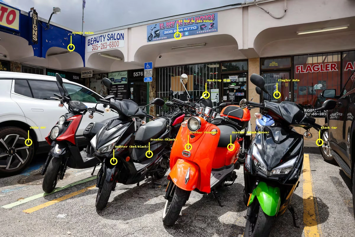
3. Feature Annotation
Visual annotation of detected features with confidence scores and geographical relevance. The AI system assigns probability scores to identified elements and their potential location indicators.
4. Location Analysis
Correlation of visual features with geographical databases to determine precise location. The system cross-references detected patterns with global datasets to generate location predictions with confidence intervals.

Core Methodology
Visual Feature Extraction
Our computer vision models analyze architectural styles, vegetation patterns, signage, vehicle types, and environmental cues to build a comprehensive visual fingerprint of the location. This process extracts thousands of features at multiple scales, from fine-grained texture patterns to macro-level scene composition.
- • Architectural style classification (Gothic, Modern, Colonial, etc.)
- • Vegetation and climate indicators
- • Transportation infrastructure patterns
- • Cultural and linguistic markers in signage
Geographical Pattern Recognition
Advanced neural networks trained on millions of globally distributed images identify unique geographical patterns, cultural markers, and regional characteristics. The system learns to associate visual patterns with specific geographical regions through deep learning techniques.
- • Regional architectural preferences and building codes
- • Climate-specific vegetation and weather patterns
- • Cultural and economic indicators
- • Urban planning and infrastructure styles
Geospatial Correlation
The system cross-references identified visual features with our comprehensive geospatial database, providing precise location estimates with confidence intervals. Multiple hypothesis testing ensures robust predictions even with ambiguous visual information.
- • Probabilistic location scoring and ranking
- • Multi-scale geographical matching (continent → country → region → city)
- • Confidence interval calculation and uncertainty quantification
- • Real-time cross-validation with known geographical databases
Performance & Results
Our geolocation intelligence system achieves remarkable accuracy across diverse image types and geographical regions. Through extensive testing on real-world datasets, we've validated the system's effectiveness in production environments.
Precise location identification within 100m radius on diverse image datasets
Real-time analysis and location estimation for production workloads
Works with any image source, regardless of metadata availability
Validation Methodology
We validated our system using a comprehensive dataset of over 100,000 images from 50+ countries, with ground truth location data verified through multiple independent sources. The evaluation covered diverse scenarios including urban environments, rural areas, historical sites, and challenging edge cases.
- • Cross-validation on images with verified GPS coordinates
- • Blind testing on images with stripped metadata
- • Performance assessment across different geographical regions
- • Stress testing with low-quality and ambiguous images
Real-World Applications
Our visual geolocation intelligence technology addresses critical needs across multiple industries and use cases, from security and intelligence to research and content verification.
Intelligence & Security
Verify image authenticity, track sources, and gather location intelligence from social media and open-source imagery for national security and law enforcement applications.
- • Threat assessment and monitoring
- • Digital forensics investigations
- • Open-source intelligence gathering
Social Media Verification
Fact-check user-generated content and verify claims about locations without relying on potentially manipulated metadata or user-provided information.
- • News verification and fact-checking
- • Content authenticity assessment
- • Misinformation detection
Asset Management
Track and verify locations of assets, properties, and infrastructure through visual documentation and automated analysis for insurance and logistics.
- • Property verification and assessment
- • Supply chain tracking
- • Infrastructure monitoring
Research & Analytics
Enhance geographical research, urban planning, and location-based analytics with automated visual geolocation capabilities for academic and commercial research.
- • Urban development studies
- • Environmental monitoring
- • Cultural heritage documentation
Technical Implementation
Our geolocation system is built on a robust, scalable architecture designed for production environments. The technology stack combines state-of-the-art computer vision models with high-performance inference engines and comprehensive geographical databases.
Core Technical Capabilities
Computer Vision Pipeline
- • Multi-scale feature extraction using CNN architectures
- • Attention mechanisms for regional focus
- • Transfer learning from large-scale geographical datasets
- • Real-time inference optimization
Geospatial Intelligence
- • Probabilistic location scoring algorithms
- • Multi-hypothesis testing and validation
- • Confidence interval estimation
- • Hierarchical geographical matching
Future Directions
As we continue to advance our geolocation intelligence capabilities, we're exploring several promising research directions that will further enhance accuracy and expand application domains.
Our roadmap includes integration of temporal analysis for historical image dating, enhanced precision for urban environments through street-level recognition, and expansion to satellite and aerial imagery for large-scale geographical analysis.
We're also investigating multimodal approaches that combine visual analysis with audio cues and other sensor data to create even more robust location identification systems for complex real-world scenarios.