Stage 1: Raw Observation - What the AI sees initially
Teaching AI to See the World
How Bower's Oceanir System Learns to Spot Any Location
Bower AI Research Team
Published: October 9, 2025
Last Updated: October 11, 2025
Research Case Study: AI Visual Intelligence
From Ordinary Photos to Smart Intelligence
Most people can recognize where a photo was taken just by looking-a street sign, a skyline, or even the color of the pavement gives it away. But for an AI, that's an entirely different challenge.
Our research team at Bower AI built a system called Oceanir-an advanced geolocation model that learns to identify places not by GPS tags, but by visual understanding. This means even if you strip an image of all its metadata, the AI can still tell where it was taken.
The Challenge: Teaching a Machine to "Notice"
When humans look at a photo of Miami, we see palm trees, Art Deco buildings, and pastel colors-our brains instantly connect those details to a memory of the place.
AI doesn't think that way. To make it "notice," we trained it on millions of images from real-world environments-each one labeled with its true coordinates. We didn't tell it what a palm tree is; we just showed it thousands of examples. Over time, it learned patterns-like the way Florida sunlight hits white stucco or how certain traffic signs appear in Los Angeles.
Visual Intelligence in Action: A Real Example
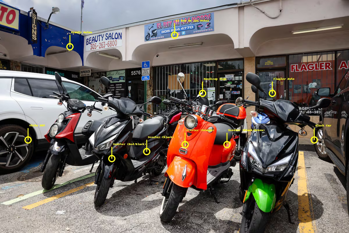
Let's see how Oceanir analyzes a real image to demonstrate its visual reasoning process. For humans, this street scene instantly suggests Miami-the motorcycle dealership, the storefronts, the architectural style. But for AI, every detail must be systematically identified and interpreted.

Stage 2: Contextual Simplification - Structural analysis
Stage 3: Semantic Recognition - AI identifies key elements
How It Works: Visual Logic, Not GPS
Stage 1: Raw Observation - Oceanir sees only color values and light patterns. It begins by segmenting the image to detect edges, shapes, and structures without any concept of meaning.
Stage 2: Contextual Simplification - Converting to grayscale removes color bias, forcing the AI to focus on spatial composition, shadows, and architectural rhythm. This helps build structural understanding of urban environments.
Stage 3: Semantic Recognition - Now the intelligence begins. The AI identifies motorcycles, reads "El Rey de las Motos" and "Flagler Auto" signage, recognizes American parking patterns, and analyzes the South Florida retail architecture. These clues converge to suggest Flagler Street, Miami.
Real-World Impact: From Investigation to Rescue
Oceanir's capabilities go far beyond curiosity. Law enforcement can verify photo locations in criminal cases. Emergency responders can locate victims from shared images. Researchers can track urban development without manual mapping. Governments can use it for disaster response, zoning, and planning.
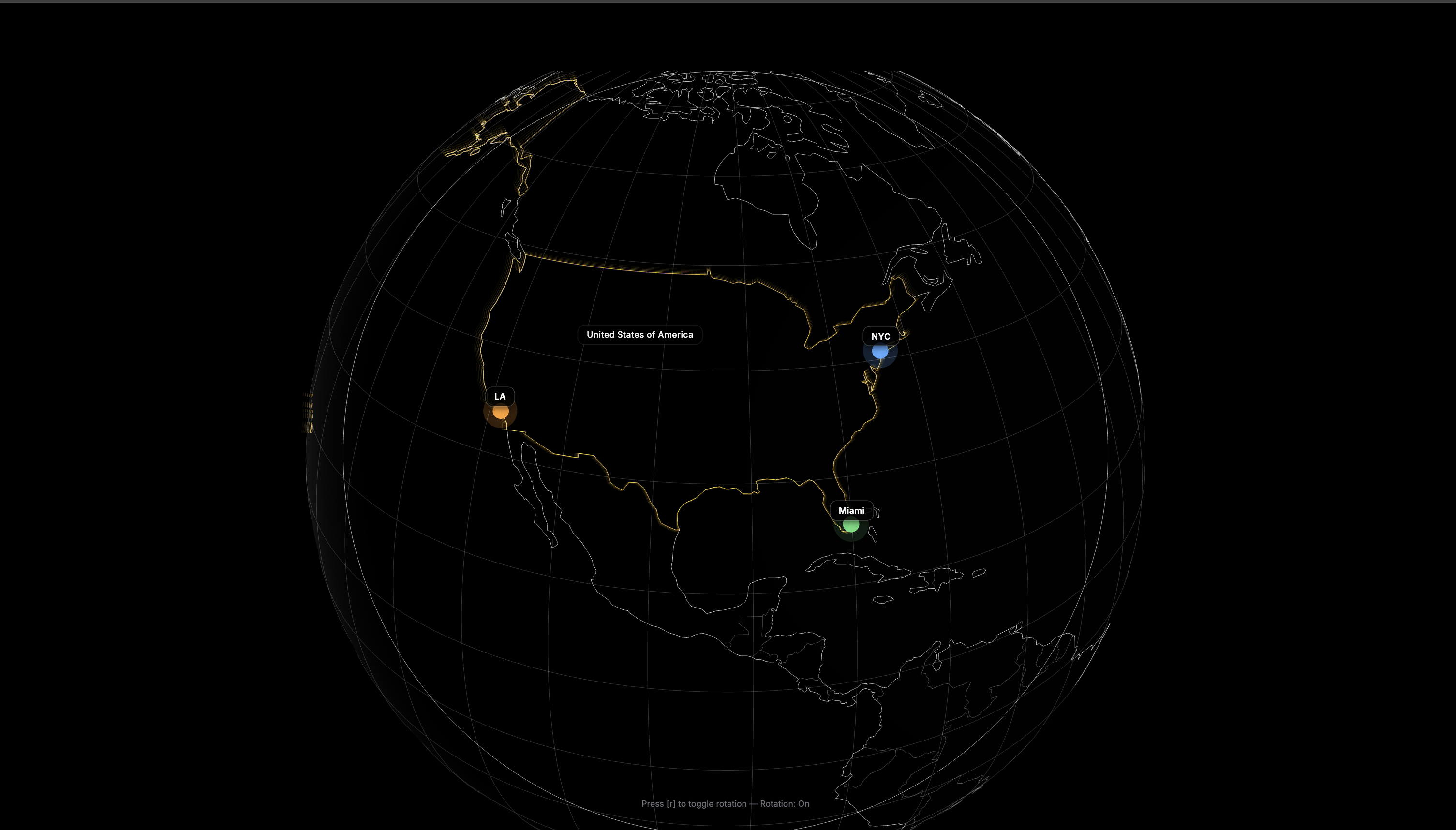
Our system demonstrated strong performance during real-world testing across Miami, New York, and Los Angeles-proving that machines can learn to see places the way humans do.
Why It's Difficult for AI but Easy for Us
Humans combine culture, language, and memory effortlessly. When we see "El Rey de las Motos," we intuitively know it suggests a Spanish-speaking area, likely Florida. AI doesn't possess intuition-it must learn to associate shapes, colors, and text patterns with geographic probability.
Where we see a sign that "feels" Miami, the AI quantifies font density, architectural curves, and parking layouts, then compares them against millions of learned references before making a geographical inference.
Training Process: How We Taught It
Oceanir's performance comes from rigorous, layered training: Visual Memory Formation using millions of urban images from Miami-Dade, New York, and Los Angeles. Scene Decomposition breaking each image into objects, text, materials, and vegetation markers.
Geospatial Reasoning cross-references visual patterns with municipal data and architectural datasets.Text-Geography Mapping recognizes language indicators like "Flagler" or "Salon" to infer regions. The result: effective location identification with efficient processing.
Privacy and Ethics
All analysis runs through temporary memory only-no permanent image storage, no human review, and fully encrypted pipelines. The system operates under strict privacy-first design, compliant with global data laws.
The Future: Teaching AI to Understand Time and Space
Next, Oceanir is learning not just where an image was taken-but when. By analyzing lighting, shadows, and environmental change, it will soon infer temporal context, enabling 3D scene reconstruction and video localization.
In Simple Terms
We're teaching AI to see the world like people do-not through numbers, but through observation, association, and reasoning. What's easy for humans-"this looks like Miami"-is a massive challenge for machines. Oceanir bridges that gap.